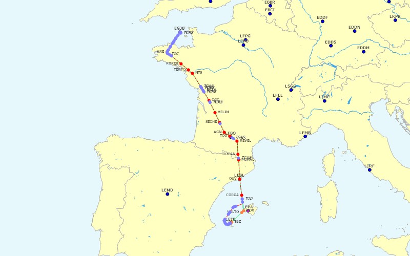
Route:
Weather:

Taxiway Path Out:

Taxiway Path In:

FS Flight Keeper
Flight EGJB to LEIB
Created On |
Changed On |
|||
07/04/2007 18:36 |
08/04/2007 07:51 |
|||
Aircraft Title |
Aircraft Type |
Tail Number |
Flight Type |
|
EuroLivewire Airlines - Airbus A320 N647EL |
Airbus A320 |
JO819 |
IFR |
|
Airline |
Flight Number |
Flight Level |
Passenger |
Cargo |
EuroLivewire |
JO819 |
FL310 |
Yes |
|
Origin Airport |
Gate |
Runway |
SID |
Transition |
EGJB - Guernsey |
Gate 21 |
09 / 27 |
18000 |
|
Destination Airport |
Gate |
Runway |
STAR |
Transition |
LEIB - Ibiza |
Gate 26 |
06 / 24 |
18000 |
|
Alternate Airport |
Pilot |
Logbook |
||
LEPA - Palma De Mallorca |
Matthew Morris (Eurolivewire Airlines) |
My Logbook |
||
| ZFW: |
108,091 lbs |
||||||
| Time OUT: |
13/12/2003 12:53 |
TAW: |
139,341 lbs |
Fuel: |
4,665 gal |
||
| Time OFF: |
13/12/2003 12:59 |
TOW: |
138,756 lbs |
Fuel: |
4,577 gal |
TO IAS: |
185mph |
| Time ON: |
13/12/2003 14:57 |
LAW: |
126,217 lbs |
Fuel: |
2,706 gal |
LA IAS: |
144mph |
| Time IN: |
13/12/2003 15:01 |
RAW: |
125,874 lbs |
Fuel: |
2,654 gal |
||
| Start mode: |
Parking origin |
End mode: |
Parking destination |
||||
| Block Time: |
02:08 |
Block Fuel: |
2,010 gal |
Distance: |
795nm / 754nm |
||
| Flight Time: |
01:58 |
Flight Fuel: |
1,872 gal |
||||
| ZFW: |
108,091 lbs |
||||||
| Gate: |
Gate 21 |
Position: |
N49* 25.9601' / W2* 35.8114' |
||||
| Altitude: |
345ft |
Season: |
Fall |
Daytime: |
Day |
Transponder: |
4357 |
| Time OUT: |
13/12/2003 12:53 |
TAW: |
139,341 lbs |
Fuel: |
4,665 gal |
Max GS: |
24mph |
| Time OFF: |
13/12/2003 12:59 |
TOW: |
138,756 lbs |
Fuel: |
4,577 gal |
TO IAS: |
185mph |
| Engine settings: |
/E1N1 103 /E1N2 102 /E2N1 103 /E2N2 102 |
||||||
| Flaps: |
14 |
VS: |
144.57 |
Pitch: |
-7.32 |
Bank: |
-0.12 |
| Runway: |
09 / 27 |
Surface: |
Asphalt (Normal) |
Heading: |
91 |
||
| OAT: |
10°C |
Dew Point: |
5°C |
Wind: |
56/12 |
Visibility: |
29nm (Normal) |
| Pressure: |
30.33 |
Altimeter: |
30.33 |
Daytime: |
Day |
||
| Spoilers: |
Down |
Autobrakes: |
RTO |
Anti-Ice: |
Off |
Flight Director: |
Off |
| Lights: |
NAV|BCN|LAND|STROBE|INST |
Autothrottle: |
Off |
||||
| Gear Up: |
1000ft / 215mph (12:59) |
Flaps Up: |
819ft / 206mph (12:59) |
||||
| Autopilot: |
870ft / 207mph Mode: VS 1800 (12:59) |
||||||
| ZFW: |
108,091 lbs |
||||||
| Gate: |
Gate 26 |
Position: |
N38* 52.5478' / E1* 22.1598' |
||||
| Altitude: |
34ft |
Season: |
Fall |
Daytime: |
Day |
Transponder: |
4357 |
| Time IN: |
13/12/2003 15:01 |
RAW: |
125,874 lbs |
Fuel: |
2,654 gal |
Max GS: |
23mph |
| Time ON: |
13/12/2003 14:57 |
LAW: |
126,217 lbs |
Fuel: |
2,706 gal |
LA IAS: |
144mph |
| Engine settings: |
/E1N1 21 /E1N2 57 /E2N1 21 /E2N2 57 |
||||||
| Flaps: |
28 |
VS: |
-166.10 |
Pitch: |
-6.27 |
Bank: |
-2.33 |
| Runway: |
06 / 24 |
Surface: |
Asphalt (Normal) |
Heading: |
67 (-3.28) |
||
| OAT: |
14°C |
Dew Point: |
13°C |
Wind: |
103/7 |
Visibility: |
16nm (Normal) |
| Pressure: |
30.09 |
Altimeter: |
30.09 |
Daytime: |
Day |
||
| Spoilers: |
Down |
Autobrakes: |
2 |
Anti-Ice: |
Off |
Flight Director: |
On |
| Lights: |
NAV|BCN|LAND|STROBE|INST |
Autothrottle: |
Armed |
||||
| Gear Down: |
1083ft / 211mph (14:56) |
Flaps Down: |
1994ft / 257mph (14:54) |
||||
| Autopilot: |
---- |
||||||
| Avg. FPS: |
10.83 |
Avg. FPS Origin/Flight/Destination: |
9.16 / 11.11 / 6.54 |
||||
| Avg. TAS: |
461mph |
Max. TAS: |
544mph |
||||
| Max. IAS Depar.: |
277mph |
Max. IAS Appr.: |
312mph |
||||
| Avg. Climb: |
1947.94 |
Max. Climb: |
2518.42 |
||||
| Avg. Descent: |
-1769.30 |
Max. Descent: |
-2421.53 |
||||
| Avg. G-Force: |
0.98 |
Min. G-Force: |
0.87 |
Max. G-Force: |
1.12 |
||
| Max. Pitch: |
-13.48 |
Max. Bank: |
32.39 |
||||
| Max. EGT: |
528°C |
Engine setting: |
102.78 |
Vibration: |
2.34 |
||
| Day Flight Time: |
01:58 |
Night Flight Time: |
00:00 |
||||
| Origin: |
EGJB 071720Z 05013KT CAVOK 11/05 Q1026 |
| |
***** METAR Report for EGJB ***** Zulu Time: 17:20 (day 07 of month) Wind: 050/13 Ceiling: Ceiling and visibility are OK Temperature: 11°C Dewpoint: 5°C Humidity: 67% Barometer: 30.30hg |
| Destination: |
LEIB 071930Z 10006KT 060V120 9999 FEW010 SCT020 14/13 Q1019 NOSIG |
| |
***** METAR Report for LEIB ***** Zulu Time: 19:30 (day 07 of month) Wind: 100/06 varying from 060 to 120 Visibility: 5.40nm or more Cloud Cover: Few at 1000ft Cloud Cover: Scattered at 2000ft Temperature: 14°C Dewpoint: 13°C Humidity: 94% Barometer: 30.09hg Trend: No significant change expected within the next two hours |
| Alternate: |
LEPA 071930Z 07003KT 040V150 9999 FEW018 13/10 Q1020 NOSIG |
| |
***** METAR Report for LEPA ***** Zulu Time: 19:30 (day 07 of month) Wind: 070/03 varying from 040 to 150 Visibility: 5.40nm or more Cloud Cover: Few at 1800ft Temperature: 13°C Dewpoint: 10°C Humidity: 83% Barometer: 30.12hg Trend: No significant change expected within the next two hours |
| Name | Type | Time | Fuel (gal) | IAS (mph) | Altitude (ft) | Heading | Wind | OAT (C) | |
| 1 | EGJB | Airport | 12:59 | 4,577 | 185 | 349 | 92 | 56/12 | 10 |
| 2 | ARE | VOR | 13:14 | 4,163 | 295 | 29899 | 204 | 290/11 | -49 |
| 3 | KORER | Intersection | 13:21 | 4,029 | 357 | 31002 | 135 | 56/14 | -50 |
| 4 | TERPO | Intersection | 13:25 | 3,966 | 350 | 31000 | 134 | 56/14 | -50 |
| 5 | NTS | VOR | 13:27 | 3,931 | 348 | 31010 | 143 | 56/14 | -50 |
| 6 | CGC | VOR | 13:40 | 3,717 | 349 | 31001 | 155 | 70/10 | -49 |
| 7 | VELIN | Intersection | 13:46 | 3,625 | 350 | 31011 | 155 | 83/27 | -50 |
| 8 | SECHE | Intersection | 13:51 | 3,551 | 353 | 31001 | 155 | 87/37 | -50 |
| 9 | AGN | VOR | 13:55 | 3,474 | 356 | 31000 | 138 | 86/47 | -50 |
| 10 | TOU | VOR | 13:58 | 3,424 | 350 | 31000 | 123 | 86/47 | -50 |
| 11 | REVEL | Intersection | 14:02 | 3,359 | 343 | 31000 | 141 | 86/47 | -50 |
| 12 | ROCAN | Intersection | 14:08 | 3,268 | 352 | 31019 | 169 | 104/61 | -51 |
| 13 | PUMAL | Intersection | 14:11 | 3,229 | 349 | 31001 | 170 | 107/60 | -51 |
| 14 | QUV | VOR | 14:19 | 3,092 | 352 | 31001 | 171 | 110/54 | -52 |
| 15 | CORDA | Intersection | 14:27 | 2,976 | 351 | 31001 | 171 | 121/40 | -52 |
| 16 | ADX | NDB | NA | NA | NA | NA | NA | NA | NA |
| 17 | VOLTO | Intersection | NA | NA | NA | NA | NA | NA | NA |
| 18 | IBZ | NDB | NA | NA | NA | NA | NA | NA | NA |
| 19 | LEIB | Airport | 14:57 | 2,706 | 142 | 33 | 67 | 103/7 | 14 |
| Name | Planned | Flight | TAF | ALOFT | ||
| 1 | EGJB | EGJB 071720Z 05013KT CAVOK 11/05 Q1026 | ||||
| 2 | ARE | Not available (LFRU) | ||||
| 3 | KORER | LFRZ 071800Z AUTO 02010KT 9999NDV NSC 16/08 Q1022 | ||||
| 4 | TERPO | LFRZ 071800Z AUTO 02010KT 9999NDV NSC 16/08 Q1022 | ||||
| 5 | NTS | LFRS 071800Z 05010KT CAVOK 17/05 Q1021 NOSIG | ||||
| 6 | CGC | LFBG NIL | ||||
| 7 | VELIN | LFBE 071800Z AUTO 27006KT 9999NDV NSC 21/07 Q1017 | ||||
| 8 | SECHE | LFBA 071830Z AUTO VRB01KT 9999NDV NCD 17/08 Q1017 | ||||
| 9 | AGN | Not available (LFDH) | ||||
| 10 | TOU | LFBO 071830Z 12004KT CAVOK 18/04 Q1017 NOSIG | ||||
| 11 | REVEL | LFMK 071830Z AUTO 07011KT 9999NDV NCD 16/07 Q1018 | ||||
| 12 | ROCAN | LFMK 071830Z AUTO 07011KT 9999NDV NCD 16/07 Q1018 | ||||
| 13 | PUMAL | LEGE 071830Z 18007KT CAVOK 14/09 Q1019 | ||||
| 14 | QUV | LEBL 071900Z VRB01KT 9999 FEW020 13/11 Q1020 NOSIG | ||||
| 15 | CORDA | LEBL 071900Z VRB01KT 9999 FEW020 13/11 Q1020 NOSIG | ||||
| 16 | ADX | |||||
| 17 | VOLTO | |||||
| 18 | IBZ | |||||
| 19 | LEIB | LEIB 071930Z 10006KT 060V120 9999 FEW010 SCT020 14/13 Q1019 NOSIG | ||||
| Type | Event | Time | Fuel (gal) | IAS (mph) | Altitude (ft) | |
| 1 | Route | Alternate Airport changed to LEPA | 12:52 | 4,665 | 0 | 345 |
| 2 | Transponder | 4357 | 12:53 | 4,665 | 0 | 345 |
| 3 | Yaw damper | On | 12:53 | 4,665 | 0 | 345 |
| 4 | Autopilot mode | VS 1800 | 12:53 | 4,665 | 0 | 345 |
| 5 | Route | Flight Plan loaded | 12:53 | 4,665 | 0 | 345 |
| 6 | Lights | NAV|BCN|LAND|STROBE|INST | 12:53 | 4,665 | 0 | 345 |
| 7 | Pitot Heat | On | 12:53 | 4,665 | 0 | 345 |
| 8 | Parking brake | Off | 12:53 | 4,665 | 0 | 345 |
| 9 | OUT | OUT 12:53 /ZFW 108,091 lbs /FOB 4,665 gal /TAW 139,341 lbs | 12:53 | 4,665 | 0 | 345 |
| 10 | Pushback | Straight | 12:53 | 4,665 | 0 | 345 |
| 11 | Engine | On | 12:54 | 4,665 | 3 | 345 |
| 12 | Engine Starter | /E1 Start /E2 Gen | 12:54 | 4,665 | 3 | 345 |
| 13 | Engine Starter | /E1 Gen /E2 Gen | 12:54 | 4,665 | 3 | 345 |
| 14 | Engine Starter | /E1 Gen /E2 Start | 12:54 | 4,664 | 3 | 345 |
| 15 | Pushback | Stopped (pushed for 61s / 266ft) | 12:54 | 4,664 | 2 | 345 |
| 16 | Flaps | 7 | 12:55 | 4,663 | 0 | 345 |
| 17 | Flaps | 14 | 12:55 | 4,663 | 0 | 345 |
| 18 | Engine Starter | /E1 Gen /E2 Gen | 12:55 | 4,662 | 0 | 345 |
| 19 | Flaps | 21 | 12:55 | 4,662 | 0 | 345 |
| 20 | Flaps | 14 | 12:55 | 4,662 | 0 | 345 |
| 21 | COM1 | 119.950 - GUERNSEY TOWER | 12:57 | 4,625 | 0 | 345 |
| 22 | Flaps | 7 | 12:58 | 4,613 | 7 | 345 |
| 23 | Flaps | 14 | 12:58 | 4,612 | 0 | 345 |
| 24 | Rotate | VR = 177mph | 12:59 | 4,579 | 154 | 345 |
| 25 | OFF | OFF 12:59 /FOB 4,577 gal /TOW 138,756 lbs | 12:59 | 4,577 | 161 | 349 |
| 26 | Altitude | Climbing at 300ft | 12:59 | 4,572 | 173 | 502 |
| 27 | Gear | going Up | 12:59 | 4,569 | 175 | 620 |
| 28 | Flaps up | after Takeoff | 12:59 | 4,564 | 179 | 819 |
| 29 | Autopilot | VS 1800 | 12:59 | 4,563 | 180 | 870 |
| 30 | Markers | Middle | 12:59 | 4,561 | 183 | 924 |
| 31 | Autopilot mode | ALT 8000|VS 1800 | 12:59 | 4,560 | 186 | 975 |
| 32 | Gear up | Up and locked after Takeoff | 12:59 | 4,559 | 187 | 1000 |
| 33 | Autopilot mode | NAV GPS|ALT 8000|VS 1800 | 12:59 | 4,558 | 192 | 1065 |
| 34 | Autothrottle | Armed | 12:59 | 4,556 | 197 | 1126 |
| 35 | Autopilot mode | NAV GPS|ALT 8000|IAS 240|VS 1800 | 12:59 | 4,555 | 202 | 1192 |
| 36 | Autopilot mode | NAV GPS|ALT 8000|IAS 240|VS 2000 | 12:59 | 4,549 | 213 | 1422 |
| 37 | Altimeter | 30.32 | 13:00 | 4,547 | 211 | 1562 |
| 38 | COM1 | 128.650 - GUERNSEY ARRIVAL | 13:00 | 4,547 | 211 | 1618 |
| 39 | Autopilot mode | NAV GPS|ALT 8000|IAS 241|VS 2000 | 13:00 | 4,546 | 211 | 1660 |
| 40 | TCAS | Traffic - Landmark 452 /DST 12.29nm /HDG 20 /ALT 4999ft /GS 175mph /VS -4ft/min | 13:00 | 4,533 | 219 | 2501 |
| 41 | TCAS | Traffic - N68112 /DST 15.00nm /HDG 330 /ALT 4497ft /GS 143mph /VS 0ft/min | 13:00 | 4,529 | 222 | 2722 |
| 42 | TCAS | Traffic - Airwave 2683 /DST 11.47nm /HDG 265 /ALT 6018ft /GS 303mph /VS -1665ft/min | 13:00 | 4,518 | 223 | 3544 |
| 43 | Pressure | 30.32 | 13:02 | 4,475 | 235 | 6493 |
| 44 | Autopilot mode | NAV GPS|ALT 8000|IAS 241 | 13:03 | 4,454 | 241 | 7926 |
| 45 | Autopilot mode | NAV GPS|ALT 18000|IAS 241|VS 1800 | 13:03 | 4,448 | 236 | 8290 |
| 46 | COM1 | 120.150 | 13:04 | 4,433 | 237 | 9292 |
| 47 | Pressure | 30.31 | 13:04 | 4,409 | 240 | 11036 |
| 48 | Lights | NAV|BCN|STROBE|INST | 13:05 | 4,401 | 239 | 11639 |
| 49 | Autopilot mode | NAV GPS|ALT 18000|IAS 295|VS 1800 | 13:05 | 4,396 | 242 | 11977 |
| 50 | Autopilot mode | NAV GPS|ALT 18000|IAS 296|VS 1800 | 13:05 | 4,376 | 276 | 12976 |
| 51 | Autopilot mode | NAV GPS|ALT 18000|IAS 296|VS 2000 | 13:06 | 4,374 | 278 | 13148 |
| 52 | Autopilot mode | NAV GPS|ALT 18000|IAS 296|VS 2100 | 13:06 | 4,371 | 278 | 13305 |
| 53 | Pressure | 30.30 | 13:06 | 4,353 | 286 | 14672 |
| 54 | Autopilot mode | ALT 18000|IAS 296|VS 2100 | 13:07 | 4,332 | 287 | 16187 |
| 55 | Pressure | 30.29 | 13:07 | 4,328 | 288 | 16474 |
| 56 | Autopilot mode | NAV GPS|ALT 18000|IAS 296|VS 2100 | 13:08 | 4,315 | 289 | 17514 |
| 57 | Pressure | 30.28 | 13:08 | 4,311 | 289 | 17810 |
| 58 | Altimeter | 29.92 | 13:08 | 4,304 | 288 | 17853 |
| 59 | Autopilot mode | NAV GPS|ALT 24000|IAS 296|VS 2100 | 13:08 | 4,302 | 289 | 17981 |
| 60 | Pressure | 30.29 | 13:09 | 4,283 | 289 | 19455 |
| 61 | Autopilot mode | NAV GPS|ALT 24000|IAS 298|VS 2100 | 13:09 | 4,282 | 289 | 19516 |
| 62 | COM1 | 124.720 | 13:09 | 4,280 | 289 | 19644 |
| 63 | NAV1 | 110.500 - MX (LFRU - LOC/DME 23) | 13:09 | 4,279 | 289 | 19763 |
| 64 | Autopilot mode | NAV GPS|ALT 24000|IAS 298|VS 2200 | 13:10 | 4,244 | 303 | 22490 |
| 65 | Autopilot mode | NAV GPS|ALT 24000|IAS 299|VS 2200 | 13:10 | 4,241 | 297 | 22804 |
| 66 | Autopilot mode | NAV GPS|ALT 30000|IAS 299|VS 2200 | 13:11 | 4,224 | 290 | 24033 |
| 67 | Autopilot mode | ALT 30000|IAS 299|VS 2200 | 13:12 | 4,190 | 275 | 27109 |
| 68 | Autopilot mode | NAV GPS|ALT 30000|IAS 299|VS 2200 | 13:12 | 4,189 | 276 | 27233 |
| 69 | Autopilot mode | ALT 30000|IAS 299|VS 2200 | 13:13 | 4,174 | 266 | 28768 |
| 70 | Navigation | ARE | 13:14 | 4,163 | 256 | 29899 |
| 71 | Weather | Not available (LFRU) | 13:14 | 4,162 | 256 | 29918 |
| 72 | Autopilot mode | ALT 31000|IAS 299|VS 2200 | 13:14 | 4,162 | 256 | 29934 |
| 73 | Autopilot mode | ALT 31000|IAS 299 | 13:14 | 4,151 | 249 | 30956 |
| 74 | Altitude | Level off at 31000ft | 13:15 | 4,136 | 270 | 31021 |
| 75 | Autopilot mode | NAV GPS|ALT 31000|IAS 299 | 13:16 | 4,120 | 292 | 31005 |
| 76 | Autopilot mode | NAV GPS|ALT 31000|IAS 302 | 13:16 | 4,118 | 293 | 31024 |
| 77 | Autopilot mode | NAV GPS|ALT 31000|IAS 304 | 13:16 | 4,107 | 296 | 31013 |
| 78 | COM1 | 120.150 | 13:16 | 4,107 | 296 | 31013 |
| 79 | COM1 | 124.800 | 13:20 | 4,043 | 303 | 30996 |
| 80 | Navigation | KORER | 13:21 | 4,029 | 310 | 31002 |
| 81 | Weather | LFRZ 071800Z AUTO 02010KT 9999NDV NSC 16/08 Q1022 | 13:21 | 4,029 | 310 | 31001 |
| 82 | COM1 | 123.750 | 13:23 | 4,008 | 304 | 31000 |
| 83 | Navigation | TERPO | 13:25 | 3,966 | 304 | 31000 |
| 84 | Weather | LFRZ 071800Z AUTO 02010KT 9999NDV NSC 16/08 Q1022 | 13:25 | 3,966 | 304 | 31000 |
| 85 | Navigation | NTS | 13:27 | 3,931 | 302 | 31010 |
| 86 | Weather | LFRS 071800Z 05010KT CAVOK 17/05 Q1021 NOSIG | 13:27 | 3,931 | 302 | 31010 |
| 87 | COM1 | 124.200 | 13:33 | 3,839 | 303 | 30999 |
| 88 | NAV2 | 113.900 - TBO (TARBES) | 13:34 | 3,829 | 303 | 31000 |
| 89 | TCAS | Traffic - World Tra 2209 /DST 14.97nm /HDG 337 /ALT 32210ft /GS 496mph /VS 15ft/min | 13:34 | 3,827 | 304 | 31000 |
| 90 | TCAS | Traffic - World Tra 2209 /DST 9.87nm /HDG 338 /ALT 32203ft /GS 496mph /VS -56ft/min | 13:34 | 3,821 | 303 | 31006 |
| 91 | TCAS | Traffic - World Tra 2209 /DST 4.60nm /HDG 342 /ALT 32184ft /GS 495mph /VS -76ft/min | 13:34 | 3,816 | 303 | 31002 |
| 92 | TCAS | Traffic - World Tra 2209 /DST 1.89nm /HDG 341 /ALT 32188ft /GS 495mph /VS 73ft/min | 13:35 | 3,813 | 303 | 31001 |
| 93 | NAV1 | 110.500 - ROC (LFDN - ILS 31) | 13:35 | 3,809 | 303 | 31000 |
| 94 | TCAS | Traffic - Orbit 8361 /DST 14.96nm /HDG 22 /ALT 29203ft /GS 483mph /VS -15ft/min | 13:36 | 3,796 | 303 | 31003 |
| 95 | TCAS | Traffic - Orbit 8361 /DST 9.82nm /HDG 25 /ALT 29195ft /GS 486mph /VS -33ft/min | 13:36 | 3,790 | 303 | 31001 |
| 96 | TCAS | Traffic - Orbit 8361 /DST 4.96nm /HDG 24 /ALT 29193ft /GS 487mph /VS 39ft/min | 13:36 | 3,783 | 304 | 31000 |
| 97 | COM1 | 125.100 | 13:40 | 3,727 | 303 | 31000 |
| 98 | Navigation | CGC | 13:40 | 3,717 | 303 | 31001 |
| 99 | Weather | LFBG NIL | 13:40 | 3,717 | 303 | 31001 |
| 100 | TCAS | Traffic - Soar 111 /DST 14.79nm /HDG 338 /ALT 30174ft /GS 509mph /VS 19ft/min | 13:41 | 3,706 | 303 | 31000 |
| 101 | TCAS | Traffic - Soar 111 /DST 9.97nm /HDG 337 /ALT 30179ft /GS 506mph /VS -25ft/min | 13:41 | 3,701 | 303 | 30999 |
| 102 | Navigation | VELIN | 13:46 | 3,625 | 304 | 31011 |
| 103 | Weather | LFBE 071800Z AUTO 27006KT 9999NDV NSC 21/07 Q1017 | 13:46 | 3,625 | 304 | 31010 |
| 104 | COM1 | 121.250 | 13:50 | 3,565 | 304 | 31000 |
| 105 | Navigation | SECHE | 13:51 | 3,551 | 307 | 31001 |
| 106 | Weather | LFBA 071830Z AUTO VRB01KT 9999NDV NCD 17/08 Q1017 | 13:51 | 3,551 | 307 | 31001 |
| 107 | Autopilot mode | NAV GPS|ALT 31000|IAS 305 | 13:51 | 3,543 | 307 | 31000 |
| 108 | Navigation | AGN | 13:55 | 3,474 | 309 | 31000 |
| 109 | Weather | Not available (LFDH) | 13:55 | 3,474 | 310 | 31001 |
| 110 | Navigation | TOU | 13:58 | 3,424 | 304 | 31000 |
| 111 | Weather | LFBO 071830Z 12004KT CAVOK 18/04 Q1017 NOSIG | 13:58 | 3,424 | 304 | 31000 |
| 112 | TCAS | Traffic - Pacifica 5186 /DST 14.87nm /HDG 57 /ALT 29129ft /GS 463mph /VS 56ft/min | 14:00 | 3,401 | 304 | 31000 |
| 113 | TCAS | Traffic - Pacifica 5186 /DST 9.98nm /HDG 60 /ALT 29097ft /GS 463mph /VS -46ft/min | 14:01 | 3,389 | 304 | 31000 |
| 114 | Navigation | REVEL | 14:02 | 3,359 | 298 | 31000 |
| 115 | Weather | LFMK 071830Z AUTO 07011KT 9999NDV NCD 16/07 Q1018 | 14:02 | 3,359 | 299 | 31000 |
| 116 | Navigation | ROCAN | 14:08 | 3,268 | 306 | 31019 |
| 117 | Weather | LFMK 071830Z AUTO 07011KT 9999NDV NCD 16/07 Q1018 | 14:08 | 3,268 | 306 | 31019 |
| 118 | TCAS | Traffic - Pacifica 172 /DST 14.99nm /HDG 245 /ALT 32184ft /GS 547mph /VS 33ft/min | 14:10 | 3,241 | 306 | 30999 |
| 119 | COM1 | 135.350 | 14:11 | 3,233 | 305 | 31002 |
| 120 | Navigation | PUMAL | 14:11 | 3,229 | 303 | 31001 |
| 121 | Weather | LEGE 071830Z 18007KT CAVOK 14/09 Q1019 | 14:11 | 3,229 | 303 | 31001 |
| 122 | Navigation | QUV | 14:19 | 3,092 | 306 | 31001 |
| 123 | Weather | LEBL 071900Z VRB01KT 9999 FEW020 13/11 Q1020 NOSIG | 14:19 | 3,092 | 306 | 31001 |
| 124 | COM1 | 120.700 | 14:27 | 2,977 | 305 | 31000 |
| 125 | Navigation | CORDA | 14:27 | 2,976 | 305 | 31001 |
| 126 | Weather | LEBL 071900Z VRB01KT 9999 FEW020 13/11 Q1020 NOSIG | 14:27 | 2,976 | 305 | 31000 |
| 127 | Altitude | Descending at 31000ft | 14:28 | 2,950 | 307 | 30860 |
| 128 | Autopilot mode | NAV GPS|ALT 19000|IAS 294|VS -1800 | 14:28 | 2,949 | 307 | 30641 |
| 129 | Autopilot mode | HDG 250|ALT 19000|IAS 294|VS -1800 | 14:30 | 2,940 | 301 | 28100 |
| 130 | Autopilot mode | HDG 250|ALT 19000|IAS 252|VS -2000 | 14:34 | 2,912 | 297 | 20056 |
| 131 | Pressure | 30.11 | 14:34 | 2,912 | 296 | 19981 |
| 132 | Autopilot mode | HDG 250|ALT 8000|IAS 252|VS -2200 | 14:35 | 2,909 | 277 | 18886 |
| 133 | Autopilot mode | HDG 247|ALT 8000|IAS 252|VS -2200 | 14:35 | 2,907 | 274 | 17915 |
| 134 | Altimeter | 30.11 | 14:35 | 2,906 | 274 | 17841 |
| 135 | Autopilot mode | HDG 215|ALT 8000|IAS 252|VS -2200 | 14:36 | 2,905 | 273 | 17319 |
| 136 | Autopilot mode | HDG 215|ALT 8000|IAS 203|VS -2200 | 14:36 | 2,903 | 259 | 16181 |
| 137 | Autopilot mode | HDG 215|ALT 8000|IAS 228|VS -2200 | 14:36 | 2,902 | 260 | 15852 |
| 138 | Pressure | 30.10 | 14:38 | 2,895 | 275 | 12702 |
| 139 | Lights | NAV|BCN|LAND|STROBE|INST | 14:39 | 2,889 | 271 | 9888 |
| 140 | Spoilers | fully Deployed | 14:39 | 2,889 | 270 | 9647 |
| 141 | Autopilot mode | HDG 215|ALT 8000|IAS 228 | 14:40 | 2,885 | 238 | 8071 |
| 142 | Spoilers | Down | 14:40 | 2,882 | 236 | 8027 |
| 143 | Autopilot mode | HDG 215|ALT 8000|IAS 222 | 14:40 | 2,880 | 234 | 8008 |
| 144 | Altitude | Level off at 8000ft | 14:40 | 2,877 | 229 | 7999 |
| 145 | Pressure | 30.09 | 14:41 | 2,869 | 223 | 8000 |
| 146 | Autopilot mode | HDG 215|ALT 8000|IAS 245 | 14:42 | 2,862 | 224 | 8002 |
| 147 | Autopilot mode | HDG 215|ALT 8000|IAS 240 | 14:42 | 2,860 | 228 | 8005 |
| 148 | COM1 | 124.750 | 14:43 | 2,847 | 237 | 8001 |
| 149 | Altitude | Descending at 8000ft | 14:47 | 2,800 | 245 | 7814 |
| 150 | Autopilot mode | HDG 215|ALT 2000|IAS 224|VS -1800 | 14:47 | 2,800 | 246 | 7725 |
| 151 | Spoilers | fully Deployed | 14:47 | 2,800 | 245 | 7648 |
| 152 | Autopilot mode | HDG 215|ALT 2000|IAS 224|VS -2000 | 14:47 | 2,800 | 243 | 7574 |
| 153 | Autopilot mode | HDG 185|ALT 2000|IAS 224|VS -2000 | 14:48 | 2,795 | 230 | 5436 |
| 154 | Autopilot mode | HDG 150|ALT 2000|IAS 224|VS -2000 | 14:48 | 2,794 | 232 | 5167 |
| 155 | Turbulence | Moderate | 14:49 | 2,789 | 227 | 3246 |
| 156 | Spoilers | Down | 14:50 | 2,786 | 225 | 2087 |
| 157 | Autopilot mode | HDG 150|ALT 2000|IAS 224 | 14:50 | 2,786 | 225 | 2084 |
| 158 | COM1 | 118.120 - PALMA APPROACH ARRIVAL | 14:50 | 2,785 | 226 | 2063 |
| 159 | Altimeter | 30.09 | 14:50 | 2,784 | 224 | 2003 |
| 160 | Turbulence | Light | 14:50 | 2,782 | 224 | 2000 |
| 161 | Altitude | Level off at 2000ft | 14:50 | 2,779 | 224 | 2000 |
| 162 | Autopilot mode | HDG 095|ALT 2000|IAS 224 | 14:51 | 2,765 | 224 | 1995 |
| 163 | Gear | going Down | 14:53 | 2,743 | 223 | 1993 |
| 164 | Gear up | Up and locked | 14:53 | 2,743 | 223 | 1995 |
| 165 | Flaps down | for Landing - 7 | 14:53 | 2,743 | 223 | 1997 |
| 166 | Autopilot mode | HDG 065|ALT 2000|IAS 224 | 14:54 | 2,739 | 223 | 2007 |
| 167 | Flaps | 0 | 14:54 | 2,733 | 223 | 2014 |
| 168 | Autopilot mode | HDG 065|ALT 2000 | 14:54 | 2,731 | 224 | 1991 |
| 169 | Flaps down | for Landing - 7 | 14:54 | 2,731 | 223 | 1994 |
| 170 | Autopilot mode | HDG 065|ALT 2000|IAS 213 | 14:54 | 2,730 | 221 | 2016 |
| 171 | COM1 | 118.500 - IBIZA TOWER | 14:54 | 2,729 | 221 | 2016 |
| 172 | Autopilot mode | HDG 065|ALT 2000|IAS 205 | 14:54 | 2,728 | 220 | 2005 |
| 173 | Autopilot mode | HDG 065|IAS 198 | 14:55 | 2,724 | 212 | 1996 |
| 174 | Yaw damper | Off | 14:55 | 2,723 | 214 | 1863 |
| 175 | Altitude | Descending at 2000ft | 14:55 | 2,723 | 214 | 1833 |
| 176 | Autopilot mode | none | 14:55 | 2,723 | 215 | 1826 |
| 177 | Flaps | 14 | 14:55 | 2,722 | 214 | 1461 |
| 178 | Flaps | 21 | 14:55 | 2,720 | 198 | 1206 |
| 179 | Gear | going Down | 14:55 | 2,720 | 198 | 1188 |
| 180 | Gear down | Down and locked for Landing | 14:56 | 2,719 | 183 | 1083 |
| 181 | Turbulence | None | 14:56 | 2,718 | 162 | 739 |
| 182 | Flaps | 28 | 14:56 | 2,712 | 170 | 421 |
| 183 | ON | ON 14:57 /FOB 2,706 gal /LAW 126,217 lbs | 14:57 | 2,706 | 125 | 33 |
| 184 | Spoilers | fully Deployed | 14:57 | 2,705 | 93 | 34 |
| 185 | Flaps | 0 | 14:57 | 2,703 | 55 | 34 |
| 186 | Spoilers | Down | 14:58 | 2,697 | 13 | 34 |
| 187 | COM1 | 121.800 - IBIZA GROUND | 14:58 | 2,695 | 12 | 34 |
| 188 | Parking brake | On | 15:01 | 2,654 | 0 | 34 |
| 189 | IN | IN 15:01 /FOB 2,654 gal /RAW 125,874 lbs | 15:01 | 2,654 | 0 | 34 |
| 190 | Engine | Off | 15:02 | 2,653 | 0 | 34 |
Field 1 |
Field 2 |
Field 3 |
Field 4 |
Field 5 |
Field 6 |
Field 7 |
Field 8 |
Field 9 |
Field 10 |
Comment |
|
Landing lights on above FL100 | -5.0% Excessive speed below FL100 during approach | -10.0% ŻŻŻŻŻŻŻŻŻŻŻŻŻŻŻŻŻŻŻŻŻŻŻŻŻŻŻŻŻŻŻŻŻŻŻŻŻŻŻŻŻŻŻŻŻŻŻŻŻŻŻŻŻŻŻŻŻŻŻŻŻŻŻŻŻŻŻŻŻŻŻŻŻŻŻŻŻŻŻŻŻŻŻŻŻŻŻ Total Score for this flight | 85.0% Landing rating | Good Pilot rating | Good |
|
Route: |
|
Weather: |
|
Taxiway Path Out: |
|
Taxiway Path In: |
|